LOUISIANA PURCHASE
FROM A PROVINCE OF FRANCE TO A STATE IN AMERICA
THE LOUISIANA PURCHASE
After the new world was discovered, Europeans came to explore the new region. Some came for wealth and others came to satisfy their desire for adventure.
In 1513 Juan Ponce de Leon, a Spanish explorer and comrade of Christopher Columbus, came to Florida and explored that area. On his second voyage to Florida, in 1521, he was killed by Indians.
Hernando de Soto was inspired with the same hopes and ambitions, and was not discouraged by Ponce de Leon’s failure. De Soto collected a large band of Spanish and Portuguese men to come to the new world in 1538. In addition to his men he brought three hundred horses, a herd of swine, and some bloodhounds. On April 25, 1541, de Soto reached the banks of the great Mississippi, a few miles below Memphis. He explored to the northwest, but no one is certain whether he reached central Missouri.
He crossed the Mississippi and pursued his course north along its west bank into the region of our state now known as New Madrid. As far as historians can tell, he was the first European to set foot on Missouri soil.
At the same time de Soto was exploring, Francisco Coronado, another Spanish explorer, led an expedition, of three hundred Spanish adventurers, mostly mounted, thoroughly armed, and well-provisioned. It is well authenticated that Coronado entered Missouri in the southern part, but how far north he went, we do not know. Some have claimed that he reached the Missouri River in the central part of the state.
PROVINCE TO STATE TIMELINE
-
1682 Explorer Robert Cavalier and Sieur de La Salle took possession of the Louisiana Province for France, in which it gained control of the Louisiana Territory in the Treaty of Fontainebleau.
-
1762 Spanish government officials assumed direct control of the Louisiana Territory.
-
1800 Spain returned the Louisiana Territory to France.
-
1803 The Louisiana Purchase was signed.
-
1805 Territory of Louisiana was established; the seat of government was St. Louis.
-
1812 A portion of the Louisiana Territory was renamed as the Territory of Missouri
-
1816 Howard County was organized from the Territory of Missouri
-
1818 Cooper County was organized from part of Howard County
-
1821 (August 10) Missouri becomes the 24th State
1762 France cedes Province of Louisiana to Spain. (Courtesy of Missouri Bicentennial Timeline)
“France ceded the Province of Louisiana to Spain through the Treaty of Fontainebleau in return for assistance in the Seven Years War against England. News of the deal traveled very slowly in the 18th century and the French governor was unaware that his territory had been delivered to another country. The French continued their work in the region by setting up trading posts and trading fur unbeknownst they were living on land now owned by Spain.”

Louisiana 1762-1800, showing boundaries of territory delivered by France to Spain under treaty of Nov. 3, 1762. State Historical Society of Missouri Map Collection.
1800 Spain returned the Louisiana Territory to France. (Courtesy of Missouri Bicentennial Timeline)
“Ownership of the Louisiana Territory became a burden to Spain as it faced a troubling economy. France, however, was rebuilding its empire in the Caribbean and in the Gulf of Mexico under its military leader Napoleon Bonaparte. France also wanted to keep the Louisiana Territory out of the hands of Great Britain, so it offered to trade territories in Tuscany, Northern Italy, for Louisiana in a secret treaty in 1800. Rumors of the secret agreement brought anger and concern among Westerners who feared that the French power would control the Mississippi River and the port of New Orleans. Efforts were underway by the U.S. government to quickly find a way to purchase the territory and secure its important trade port and navigation waters that led to the Gulf of Mexico.
1803 Louisiana Purchase is Complete (Courtesy of Missouri Bicentennial Timeline)
“The Louisiana Purchase by the United States from France would nearly double the size of the U.S. and became one of the largest land transactions in history. Rich in gold, silver and fertile soil, as well as large tracts of forests, the land brought much wealth to the country. With American independence from Great Britain, France had concerns whether it could maintain and defend a colony on U.S. soil and Napoleon needed money to renew a war against Great Britain. President Jefferson sent James Monroe to Paris to negotiate the treaty for the Louisiana Purchase that was signed April 30, 1803. In exchange for almost 828,000 square miles, the United States would pay France $11,250,000 and assume $3,750,000 worth of American claims against France. Both France and Spain would be granted access to all ports of Louisiana. The U.S. agreed to incorporate Louisiana into the Union as soon as possible”.
The United States purchased a total of 828,000 square miles of land from France for 15 Million dollars, which is approximately eighteen dollars per square mile. This purchase increased the size of the United States from the Mississippi River westward to include what are now the states of Missouri, Arkansas, Iowa, Oklahoma, Kansas and Nebraska, plus large portions of what are now North and South Dakota, Montana, Wyoming and Colorado, east of the Continental Divide. Also included were the portions of Minnesota west of the Mississippi River, the northeastern section of New Mexico, the northern part of Texas, New Orleans and portions of Louisiana west of the Mississippi River. It also included small portions of the present Canadian provinces of Alberta and Saskatchewan.
Click here for the The Story of the Louisiana Purchase
Click here for the Map of size of LOUISIANA PURCHASE and extensive background

Louisiana 1803-1819, showing boundaries of the Louisiana Purchase Treaty in 1803.
State Historical Society of Missouri Map Collection. 1803-1819


The land that is now known as Missouri, was a section of the area that was once part of the Louisiana Purchase. This 1804 map shows the District of Louisiana.
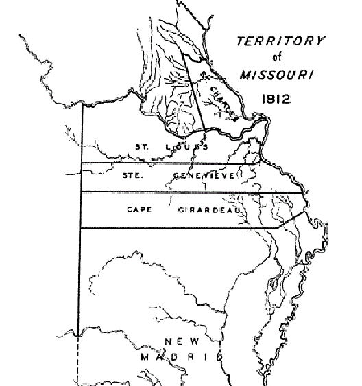
In 1805 the Territory of Louisiana was established; the seat of government was St. Louis. In 1812 a portion of the Territory of Louisiana became the Territory of Missouri.
(1805) President Jefferson appoints James Wilkinson to be the first governor of the newly-formed Louisiana Territory at the encouragement of his vice president, Aaron Burr. Once appointed, Wilkinson and Burr plot ways to set up a new country west of the Appalachian Mountains, separate from the United States. Before becoming territorial governor, Wilkinson had been hired a "Spanish Secret Agent 13" by the Spanish governor in New Orleans to promote immigration to Spanish lands in Missouri. Wilkinson was removed from office two years later in 1807 due to corruption, treason and multiple transgressions.
Missouri Life “Meet Missouri's First Governors”
1808 Osage nation First Land Treaty (Courtesy of Missouri Bicentennial Timeline)
In 1812, the Missouri Territory was created as a separate territory out of the District of Louisiana land. The entire state was called The Missouri Territory, until it was admitted into the Union, once it was sectioned off from the remaining Louisiana Purchase land. At this time, Howard County was still part of the 5 large counties that made up the Missouri Territory. The 5 Counties were St. Louis, St. Charles, New Madrid, St. Genevieve, and Cape Girardeau.
References:
The Territorial Papers of the United States, Territory of Louisiana-Missouri, 1806 -1814
The Territorial Papers of the United States, Territory of Louisiana Missouri, 1815-1816.
Missouri Historical Maps District of Louisiana, 1804 Missouri Territory, in 1812 Missouri Territory, in 1816 Missouri Territory in 1819 and State of Missouri 1n 1821
In 1816 the Missouri Territory was divided into 7 counties: Lawrence, Cape Girardeau, Washington, St. Louis, St. Charles, New Madrid, and Howard.